


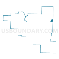
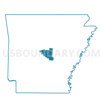
Voting District 46, Pulaski County, Arkansas
About
Outline

Summary
| Unique Area Identifier | 527843 |
| Name | Voting District 46 |
| County | Pulaski County |
| State | Arkansas |
| Area (square miles) | 2.24 |
| Land Area (square miles) | 2.24 |
| Water Area (square miles) | 0.00 |
| % of Land Area | 100.00 |
| % of Water Area | 0.00 |
| Latitude of the Internal Point | 34.85378290 |
| Longtitude of the Internal Point | -92.08865590 |
Maps

Graphs
Select a template below for downloading or customizing gragh for Voting District 46, Pulaski County, Arkansas


Neighbors
Neighoring Voting District (by Name) Neighboring Voting District on the Map
- Voting District 35, Pulaski County, AR
- Voting District 36, Pulaski County, AR
- Voting District 38, Pulaski County, AR
- Voting District 45, Pulaski County, AR
- Voting District 47, Pulaski County, AR
- GRAY Voting District, Lonoke County, AR
- PULASKI Voting District, Lonoke County, AR
Top 10 Neighboring County Subdivision (by Population) Neighboring County Subdivision on the Map
- Hill township, Pulaski County, AR (162,764)
- Gray township, Lonoke County, AR (3,375)
- Pulaski township, Lonoke County, AR (475)
Top 10 Neighboring Place (by Population) Neighboring Place on the Map
Top 10 Neighboring Unified School District (by Population) Neighboring Unified School District on the Map
Top 10 Neighboring State Legislative District Lower Chamber (by Population) Neighboring State Legislative District Lower Chamber on the Map
- State House District 48, AR (41,391)
- State House District 15, AR (29,068)
- State House District 44, AR (25,697)
- State House District 39, AR (24,419)
Top 10 Neighboring State Legislative District Upper Chamber (by Population) Neighboring State Legislative District Upper Chamber on the Map
- State Senate District 28, AR (91,744)
- State Senate District 29, AR (85,160)
- State Senate District 34, AR (71,300)
Top 10 Neighboring 111th Congressional District (by Population) Neighboring 111th Congressional District on the Map
Top 10 Neighboring Census Tract (by Population) Neighboring Census Tract on the Map
- Census Tract 36.07, Pulaski County, AR (5,004)
- Census Tract 36.08, Pulaski County, AR (4,732)
- Census Tract 36.09, Pulaski County, AR (4,068)
- Census Tract 203.01, Lonoke County, AR (3,977)
- Census Tract 203.02, Lonoke County, AR (3,750)
- Census Tract 36.06, Pulaski County, AR (2,907)
- Census Tract 206, Lonoke County, AR (1,815)